Dennis took geology in colleg
 e but I was never a devotee of rocks. Have you ever heard of a waterpocket fold? If you are like me and have no idea, the National Park Service describes it as a wrinkle in the Earth’s surface. They also explain it as a giant buckle in the Earth’s crust that stretches across south-central Utah. The same force that created the Colorado Plateau caused this vast warping of rock, created 65 million years ago.
Capitol Reef preserves the fold and the eroded jumble of rocks, cliffs and canyons. When you drive through the Park, you think about the Earth after a colossal earthquake. While there are no skyscrapers here, there is still evidence that a major eruption caused things to fall, crack and tip.
Capitol Reef is named for a particularly colorful section of the fold where rounded Navajo sandstone forms capitol-like domes and sheer cliffs.
 We stopped, as always, in the Visitors’ Center to get the skinny on the Park. It is not our intent to spend an entire day here, as we want to move towards Arches National Park while it is still early. The friendly park ranger gave us the lowdown, including information about a 20 mile round trip scenic drive. One of the “highlights” of the drive is a stop at the Gifford House, which sells homemade bread, pics and scones. Since we didn’t have breakfast yet, this sounds like a real winner. We begin the trek down the road and drive along some old orchards. In the late 1800’s the Mormons had a settlement in this area, called “Fruita”. It was so named because of the ground that provided nourishment for pear, peach, apple, apricot and cherry trees. Heirloom varieties are still grown here and if you are here during harvest time you can eat all you want while walking in the orchards and pay for whatever you pick to take with you. What a deal. The trees created a beautiful addition to some pictures of the rock formations. The morning light created gliste
 ning trees.
At the Gifford House we each picked out a scone and then purchased a small pie for dessert tonight. The pies are really individual small pies but if we split this one, then all the calories will fall out and we won’t have to worry. Right.
 The scenic drive is a somewhat rough road and we can hear the dishes clanging in the cupboards and the
  wastebasket has begun to roam around the motor home. Good thing it is empty. We stop to take some shots and I find five different flowers that are in full bloom. Beautiful. We follow the road until the
  pavement ends. There is a parking lot and an opportunity to photograph one of the parks geological delights: the Egyptian
  Temple. We now have to decide if we are going to
  risk driving down the remaining portion of the road, which has deteriorated, into a rough dirt road. We have been told that these last couple miles are the best and that the road drives through a rocky gorge. Oh, what the heck, let’s go. In the first quarter mile, we
  have to cross a somewhat wet area. Not only is it wet; it is bumpy. Too late to turn around. There is no room. The only alternative to moving forward is to back up the vehicle. Not a good idea. Forge ahead. Talk about twists and turns! There is barely enough room for cars to pass
  each other. Rocks that appear to have tumbled are at the side of the road. When I say “rocks”, I am talking 20 foot rocks. You look up and see teetering
  boulders, cracked monoliths and you wonder, “When did they fall? Could one fall on us today?” There would be no ducking. I’m not talking about the “falling rock” signs you see along
 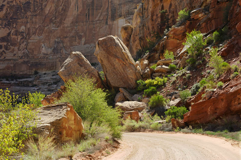 modern highways. I am talking about a 20-foot wide road traversing through massive rock formations. It doesn’t seem to bother Dennis a bit, but I must confess that it made me more than a little anxious. I can stand on the edge of a cliff where a 2,000-foot drop is but a step away. That doesn’t bother me because I know that unless I take a misstep, I am perfectly safe. Here, I am at the mercy of the rock gods. What if the vibration of the motor home shook the rocks or what if ….STOP IT! I keep looking for Fred Flintstone and Barney Rubble. The Slate Rock and Gravel Company must be out here somewhere! We get some great pictures through the windshield and by getting out of the motor home. We see a wonderful angle for the “Golden Throne.” We finally emerge from the gorge and find a trailhead with lots of cars…no motor homes… but lots of cars. Lots of Subarus. Hikers must love them like the commercials on television claim.
 We wind our way back through the gorge and then back up the scenic drive. There is a great shot of a barn near the orchards we spot on the way back. We get on the main highway, Scenic
  Byway 24. Along the way, we catch the old Fruita Schoolhouse, the Capitol Dome and a Petroglyph display. We also see the Fremont River, winding down from Capitol Dome and some mule deer grazing.
 Once leaving the Park, we continue east on Byway 24
  to the town of Hanksville. We stopped in the Bull Mountain Market for some groceries and then head northeast towards Arches National Park. We stop for lunch on the side of the road overlooking some
  stunning vistas.
We hopped on I-70 (felt weird to be on a wide open highway) for 30 miles. We head south for 25 miles towards Moab Utah. Moab is the hub that was given life through its proximity to Arches National Park. Every hotel chain, fast food chain and lots of mom and pop restaurants dot the main drag. We stopped in the Park to get the lowdown on transportation, sights to see, etc. We wanted to camp in the Park but no campsites were available by the time we got there (3:00) so we found a campground outside the park.
Now, only the women reading this can appreciate my next sentence. I asked the clerk at the registration desk in the RV park if there was a nail place close by as it looked like lots of things were within walking distance to the campground. She said there was and gave me directions. Dennis wanted to take a nap anyway, so why not? It has been three weeks since I had my nails done (guys, not the kind you hammer) and it showed. Hallelujah!
We study the Arches map and plot our strategy for tomorrow. Even though we are both somewhat suffering from “rock overload”, we are looking forward to this gem.


No comments:
Post a Comment